There are many times when I work on this blog that I feel inadequate in my abilities to describe an adventure that Tim and I have been on. My vocabulary and literary skills are very evidently lacking.
This time Tim took me to a part of Olympic National Park that can arguably be the most beautiful place I have ever been. Only Poetry could do it justice. I will do my best to let the pictures fill in where my meager writing fails to express what I saw and experienced on our trip to Enchanted Valley.
The trail head to our first adventure of summer 2012 is out near the Ho Rain forest (sort of) about a four hour trip by car. We first stopped at the Quinault Ranger Station, on Lake Quinault, for our permit--yes it was raining--then traveled several miles further in on a dirt road. Our white car, wasn't any more... and the parking area was full--well almost!
 |
| We later drove through rain that served as our car wash! |
I wonder what Tim was thinking when we took this before picture. I can be a total grouch when I hike. I have developed plantar fasciitis in my right foot (last summer's pool injury caused the tendons on the bottom of my foot to heal tight) so walking a long ways can be painful for me. But I am determined to see this beautiful place, deep into the Olympics (and I am determined to not make Tim regret taking me)!
You cannot see in this picture the mileage for each of the places where we headed. We would hike six miles on day one, six on day two, six on day three, six on day four. I had never backpacked a multiple overnighter before and this one was going to be wet too!
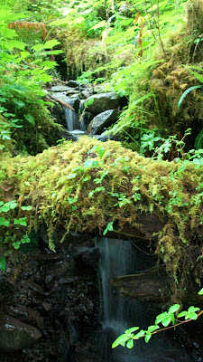 |
| We crossed many small streams along the way |
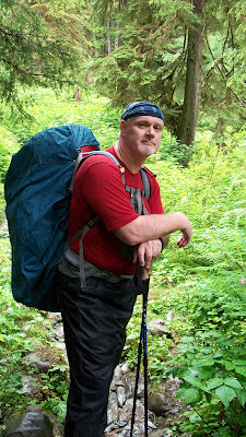 |
| It was wet, but warm. The rain pants helped to keep the mud off our clothes. Glamour huh? |
 |
| Nearing the Pony Bridge 2.5 miles in |
 |
| Pony Bridge--literally a place for the horses which were allowed, but not seen, to cross the river |
 |
| Tim on the bridge. The camera fore-shortens the distance to the bottom. |
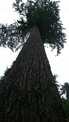
This area of the park has never been logged--too remote and the river to narrow. The trees were immense, several hundred feet tall and maybe six-people-holding-hands, standing at the bottom of the trees- in diameter. It felt like the primordial forest. It misted on us off and on, which felt good on our sweaty skin.
The goal was to get to Camp O'Neil , six-ish miles into our trip. I was pretty done about a mile before that, so, that amazing man of mine, found this great place along the river and made camp just in time, before the heavens opened! Tim is the man you want to take on backpacking trips, because he does everything for you! I was shivering a few minutes after the tent was up (it is what I do when I hike), so he just let me change out of my wet stuff and climb into my sleeping bag. Dinner in bed! Not a great idea considering the bears, but I was very careful!
This is the new tent that was purchased specifically for this trip. It is very lightweight (about 1.5 lbs) and despite its odd shape, very roomy!
Although stiff and sore in the morning, the next day's hike was easier for me. Thank goodness for ibuprofen! The sun even came out on day two! We kept the rain pants on however, still lots of mud to navigate...
 |
| Although this picture shows our muddy boots, it does not show that the muddy mess that went up to my pant knees! |
 |
| I told you the trees were big out here! |
Except for the Pony Bridge at mile 2.5, the trail mostly follows the east fork of the Quinnault. To get into the valley, you had to cross it again. The last time Tim was here (by himself I might add), there was not bridge--he had to ford the river.
(Now you will have to use a bit of imagination for the photos of the valley. My camera did not have a UV filter so imagine them way more green and the sky a vibrant blue...)
Once crossing the river we got some peek-a-boo hints of what was just through the trees...
We passed through a section of thinning, younger trees and had to cross the many rivulets that joined into the river. Up ahead we got a look at the chalet that was built on site at the turn of the century still standing.
The valley is at about 3,000 feet with cliffs rising straight up to the snowline at 5,000 feet. We never did get to see the tops of mountains around us. 15-20 waterfalls everywhere on the rock faces spilling out from the snow melt above.
 |
| You'd think that was the top of the cliff, but it is just the snow line. White mountain goats dotted the rock faces too. |
 |
| No ranger at the chalet. There is an emergency shelter space available in part of the chalet. In winter the chalet is basically buried. |
 |
| There is room in the valley for a lot of backpackers and horses. Out houses even! Pretty posh! |
I guess at one time there has been running (non-potable water) here, but not today--We pumped ours from the river--it was cold and very refreshing!
Camp site for night number two--13.5 miles. Everywhere we sat we heard running water, enjoyed wildflowers and the bugs didn't bite. The sun was out so we could dry out our gear, read a book, eat mint oreos and drink Hawaiian punch flavored water. Bliss!
 |
| This is a gnarly old maple that I liked the looks of. |
After dinner we hiked up to the other end of the valley to see what we could see.
The valley cliffs are straight up and you get ideas in your head that you are in the PNW version of Valley of the Lost. When the avalanches of snow come off the top, they push the air ahead of them and break the trees in the valley below. Snow didn't do this--air did!
You cannot see it in this photo, but over Tim's shoulder is a view of Mount Anderson and just 20 miles further, the Dosewalips trailhead--practically our backdoor...
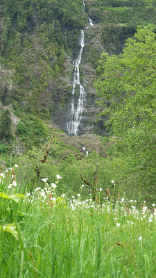 |
| View from our campsite |
Funny how the hike back seems quicker when you know some of the landmarks along the way. We had spotted this elk antler on the way in and it was still there on the way out. It is illegal to remove antlers from the park, so no souvenir this time!
 |
| This picnic table is the marker of the end of the original road that they were once going to build into the heart of ONP. I am glad that road was never built! 2.5 miles to the car! |
Yup! I did it! 13.5 miles in one day! Thank goodness for the two Excedrin that I took after lunch!
What a beautiful place Tim took me to! I would go back again. Over the entire trip we only gained about 1500 feet in elevation--so it was basically a walk in the park. A long walk, but an enchanted one!
Love you all! Happy adventures everyone!
PS Our next outing is to Lake Ozette and the PNW beaches--mental note to bring my bucket! I need more rocks.... :) We're taking the canoe too!
PSS The hot shower WAS bliss! I have never smelled sooo bad!






you did it!!!! oh man that place is just beautiful.;) loved the adventure you took us on..hope your foot is oTay!!! have a wonderful week my friend;) p.s. am I on your VT list? please say its so..;)
ReplyDeleteLove hearing about your adventures with Dad. You two are so much more fun that we are all gone! Pictures are great too. Blow them up and put them in a frame for me.
ReplyDeleteDang. Can I go there next time I come visit??? Please...
ReplyDelete