
I am not sure when it happened, but somewhere along the way visiting a pyramid became a "bucket item" for me. My sweet husband decided that we needed a nice long vacation to a place where the sun shines, so we made plans to visit the Yucatan over my spring break! Sunshine---check, pyramids ---- check! Following is our epic journey; lots of pictures, so settle in!
Day One :Travel to Mexico
So we cheated a little, Tim worked his Friday and we took the red eye to Cozumel, Mexico with lay overs in San Francisco and Houston. Sounds like a pain, but it was nice to get out and walk around between flights. We arrived, walked across the tarmac in Cozumel and definitely knew we weren't in Kansas anymore; armed guards with machine guns watched as we entered the terminal and checked in through Mexican customs. Very sobering, but it was all good!
Tim Jr. warned us about the guys waiting to sell us everything as we came out of the terminal, but they were so tricky. One guy asked us if we had transportation yet, we responded not yet (although we had a plan), and directed us to an official looking gentleman at a desk (hey we were being obedient tourists) and consequently had to sit through a sales pitch for packages to go see things in the area.....once we firmly extricated ourselves from this nice (and determined) sales person doing his job, we noted that we did not have a ride available to us...all of those nice hotel vans were gone.....fortunately, we knew that by walking a block from the airport, we would find a cab to our resort! Cabs are not allowed to pick-up passengers at the airport, so you HAVE to walk a short distance or accept a package deal to get a ride to your hotel!
We were a hundred yards from the doors, when our first cab swooped by and motioned to where he could pick us up! Tim used his Spanish skills to determine price and we were at our hotel by 10:30 am. A little sweaty and a lot tired, but determined to not waste a day!

The lobby looked out over the pool and beach. Our rooms wouldn't be ready until 1 pm so Tim changed into his suit (I still don't know why I didn't), stowed our bags into lockup and hung out at the pool. All you could drink and eat already available too! Even though we hung out in the shade, without sunscreen we still caught too much sun!

Notice the 5 o'clock shadow on my sweetie...we couldn't get over how beautiful the water was!


Views of the resort and beach from our first room....yes, our first room. They tried to book us into a room with two full beds, not a king as reserved. Yeah, that wasn't going to fly....so day two, we had to move rooms, and we didn't unpack yet. But we slept like the dead!
Day Two: Pool and Snorkeling

Our personal itinerary was planned to hang out at the pool and beach on our first full day so we would be rested and relaxed before we went out and about to play! Good call!

Our hotel was at the north end of the island, facing Playa del Carmen (on mainland Yucatan) across the straight. The beaches are made of ironstone with no natural sand to speak of; they have to truck it in... and ouch, the rock is well named! It was a trick to put your fins on while the waves batted you around!

The snorkeling was fabulous and free. We saw sting rays, squid changing colors, flounder, urchins, all kinds of fish (mostly smaller, but some kind of big and intimidating) and coral! Tim and I held hands as we paddled about so we could find each other and point and comment as we went (and so I wouldn't get freaked---images of jaws---stupid movie!)
Day Three: Playa del Carmen, Coba, Chichen Itza
The plan for this day was to ride the ferry into Playa del Carmen on the mainland, rent a car and drive to the ruins at Coba, (about 2 hours), then back to the coast and the ruins of Tulum. We had heard from others about driving in Mexico and Tim was a bit nervous about navigation and staying safe, but hey, this is adventurers with Tim and Peggy, so we girded up our loins and set out!
 |
| Waiting in the ferry terminal in San Miguel, Cozumel about 8 am. The ferry cost about $32 US per person, round-trip. |
  |
| The ferry was very nice, we opted to sit on top. Good thing too, the water was choppy and my sweetie got queezy! |

 |
| Ferry dock views in Playa del Carmen |
 |
| Plaza at Playa del Carmen. This is a night town with all kinds of productions going on in the evenings. |
The car rental place was located walking distance from the Ferry and we were the first customer of the day when they opened at 8 am. Once again, spanish is a helpful language to have while visiting Mexico! Tim figured out really quickly that lane markers are only suggestions and that when a car comes up behind you and flashes their lights, you should move into the shoulder and let them pass! Oh and speed bumps are more like....blockades; you have to come to almost a complete stop and inch over most of them or you will slam your bumper! He did great! Yes we got FULL coverage!
Having left the hotel before breakfast was served, we got hungry and assumed that we could not eat the local, yummy smelling foods. So before getting to Coba, we ventured into a supermarket in Tulum and got bottled water, pan, fruit and muffins.
Having left the hotel before breakfast was served, we got hungry and assumed that we could not eat the local, yummy smelling foods. So before getting to Coba, we ventured into a supermarket in Tulum and got bottled water, pan, fruit and muffins.
Amazingly, with the map in Tim's head, and signs for the Mayan ruins, we were able to make our first destination at Coba without mishap! I was blown away with what we saw...
 |
| Thick but not tall jungle right up to the roadside. |
 |
| Ocassionally there were breaks in the jungle where people had cleared for homesteads. Ruins and rocks everywhere, hidden by the fauna. |
This was our first ruin, so my sweet Timmie, popped for the private 45 minute guide. Coba area is huge, and the guide helped us interpret what we were seeing. The guide, Juan, was of Mayan descent and very informative. I couldn't retain everything, but I will share the gist:
Coba (in the Mayan language means water stirred by the wind) was settled around 100 BC around a collection of small lagoons; it is a good location as the Yucatan Peninsula is virtually devoid of above ground water. Coba developed into an important trade hub, and had a particularly close connection with what is present day Guatemala. At its peak, around 600-800 AD, Coba was the largest urban center in the northern lowlands with 40,000 residents and over 6,000 structures spread over 31 square miles with only 2% of the area excavated. It was eventually toppled by the Itzas following a protracted war in the mid 800's. The city was all but abandoned and was briefly reinhabited in the 12th century, but was abandoned again, and covered in a blanket of vegetation, by the time of the Spanish conquest. The entire site is surrounded by thick jungle.
La Iglesia (the Church) is 74 feet high . It was built in several phases and is definitely Mayan with rounded corners. We couldn't climb this one. You can see from the excavations that the building is not solid. The cut-a-ways show rooms and passages beneath the stairs, etc.


The lower front of La Iglesia had deep steps that the guide told us were used for the people to sit upon and listen to sermons or town meetings, or maybe celebrations The whole structure was made of rock gathered and assembled using mortar made of all kinds of stuff including sap from trees. Look closely at the picture on the right and you can see some blue color. This is all that is left of this particular mural. They would paint on stucco over the rocks! Colors were made of earth materials traded from all over the region.
 |
After leaving the area (at Iglesia,) we walked through a tunnel in the wall; it was like walking through air conditioning! As you can tell, the Mayan were not six feet tall like Tim!
We next visited with the guide at the ball courts --there were two of them. As you will see, they are small, like practice fields, compared with what you find at Chichen Itza, but have similar features.
 |
| Notice the rock hoop on the upper left |
 |
| Tim and guide, Juan standing between both walls with hoops |
 |
| Another view giving an idea of size |
 |
| There is a rock carving placed in the sloped wall of a player dressed with feathers etc. |
 |
| The guide said that this figure was of the sun god; there was another one on the other side of some broad steps with its eyes closed --(it was damaged) which he said stood for the god of the night--the moon. The open eyes basically represented eternal life, and the closed eyes for death. At the end of these broad steps were large rock wells. The guide told us that the winners (something about it being a priveledge) of each match were sacrificed on these steps with the blood running into the wells. Knowing in the last days of the Book of Mormon people and how they perverted the original commandments, I thought that originally this may have been a place where the Law of Moses sacrifice of animals could have been. |
Directly across from the ball fields where some pedi-cabs for rent that could take us to see the rest of Coba site that had been excavated, and my first pyramid! The guide left us, and the valiant pedi-cab Mayan gentleman pedeled Tim and I up and down the hills!


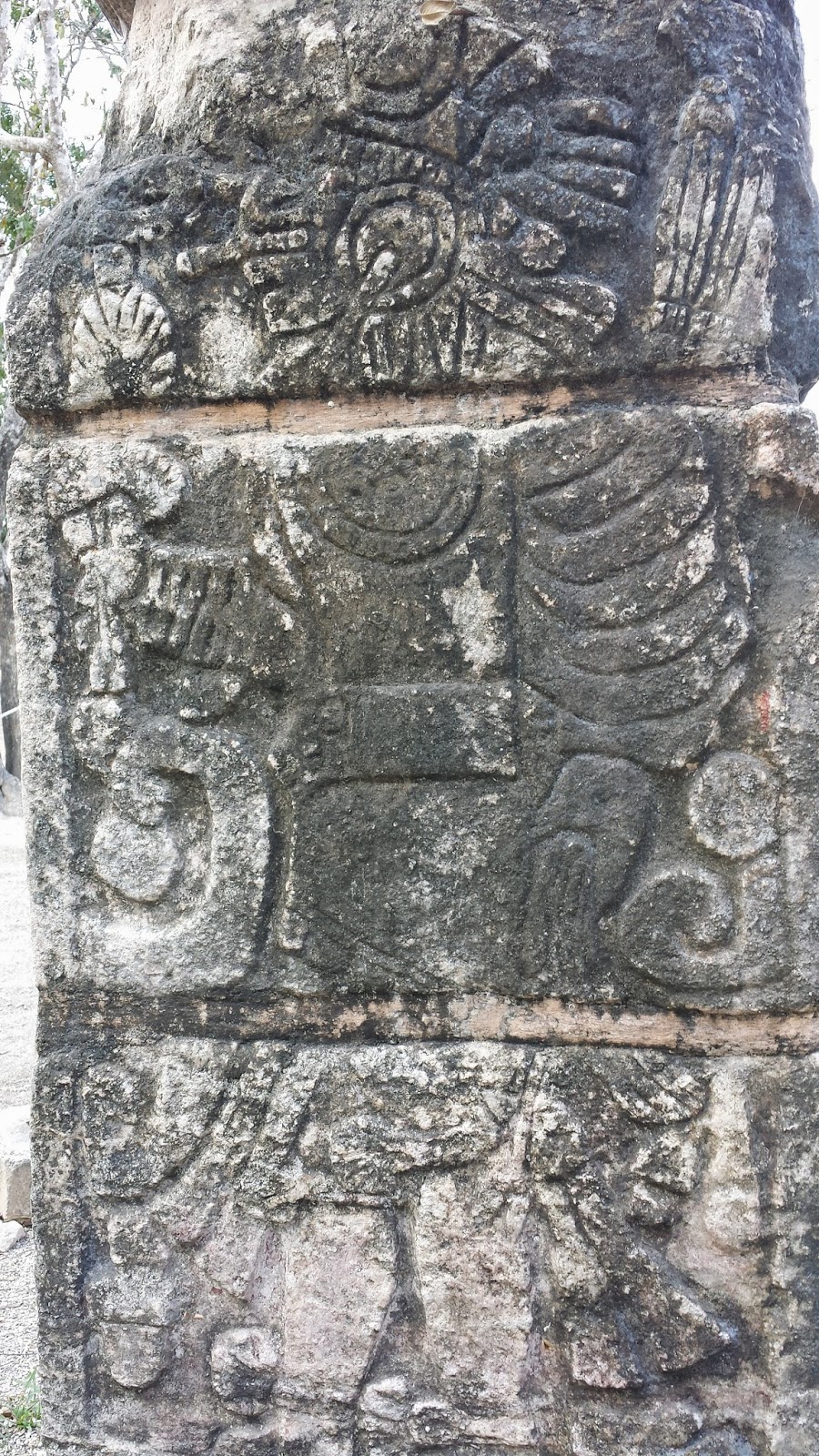
Left is Xaibe (Mayan for crossroads) which may have been a watchtower or observatory used to view the night skies. It is very rounded. The rock (middle) below the palapa roof is called a stelae. It is depicting a figure in an elaborate costume and headdress, holding a large ornate scepter in his arms, signifying that he is an ahau or high lord or ruler. The date inscribed on it November 30, 780-- is the latest date yet found in Coba.
 |
| As we were peddled along, we would see these mounds of rock and realized that this is part of the 98% of Coba not yet excavated. They look like rock piles, but were once buildings where people worked or lived. They were everywhere. |
One or two miles later we came to Nohuch Mul (Mayan for big mound). It is 138 feet above the forest floor, the equivalent of a 12 story building. The pictures do not really show you how impressive it is, all I could say was wow! It is the second highest structure on the Yucatan peninsula (Calakmul in Campeche is 10 meters higher) The steps were uneven and steep; you had to concentrate to climb and not fall! It is one of the few pyramids you can still go up! And we climbed it all the way to the top!


The view from the top was impressive! Our video will not download via email (our computer is too old to do it the easy way) from our phone, but you could see the lagoons and a flat green forest spreading almost uninterrupted in every direction with all of its secrets below.

A zip line down would have been fun, but no luck. One careful step at a time. I am short, so some of the stops were beyond my balance; I would have to sit and slide to be safe. The rope wouldn't have done too much good for me, so we just went slowly!
There was a ton to see, but we had another ruin to visit. Daylight was a-wasting! On to Chichen Itza!

I will admit to you that we actually considered not going to Chichen Itza. We were so impressed with Coba and we were naive enough to think that all the ruins would be similar. Yeah, wrong. Um--Wow again!
Chichen Itza (Mayan for well of the Itza) is Mayan but was built over by the Toltec around 1000AD. Most notable of its many structures was the four-sided pyramid called El Castillo or Temple of Kukulcan. We read that it was built according to strict astronomical guidelines. There are nine levels, divided by the central staircase, making 18 platforms--the number of months in the Maya calendar. Each of the four sides has 91 steps, which added together, along with the platform on top, totaling 365--one for each day of the year. There are 52 inset panels on each face of the structure, equal to the number of years in each cycle of the Mayan Calendar round. On the spring and autumn equinoxes the afternoon sun lights up a bright zig-zag strip on the outside wall of the north staircase as well as the giant serpent heads at the base, giving the appearance of a serpent slithering down the steps. We were told that an evening light show would depict this, but we opted not to stay for it. We took pictures of all four sides and then some! You used to be able to climb this pyramid but in 2005 an elderly tourist fell and died after tumbling from near the top of the pyramid to the ground. Many sites are now closed to climbing so we are lucky to have been able to go up at Coba!
Chichen Itza (Mayan for well of the Itza) is Mayan but was built over by the Toltec around 1000AD. Most notable of its many structures was the four-sided pyramid called El Castillo or Temple of Kukulcan. We read that it was built according to strict astronomical guidelines. There are nine levels, divided by the central staircase, making 18 platforms--the number of months in the Maya calendar. Each of the four sides has 91 steps, which added together, along with the platform on top, totaling 365--one for each day of the year. There are 52 inset panels on each face of the structure, equal to the number of years in each cycle of the Mayan Calendar round. On the spring and autumn equinoxes the afternoon sun lights up a bright zig-zag strip on the outside wall of the north staircase as well as the giant serpent heads at the base, giving the appearance of a serpent slithering down the steps. We were told that an evening light show would depict this, but we opted not to stay for it. We took pictures of all four sides and then some! You used to be able to climb this pyramid but in 2005 an elderly tourist fell and died after tumbling from near the top of the pyramid to the ground. Many sites are now closed to climbing so we are lucky to have been able to go up at Coba!


The guidebook said that deep inside, up a steep narrow staircase there are several chambers, inside one is a red-painted, jade-studded bench in the figure of a jaguar, which may have served as a throne. That would have been cool to see, but it was closed to tourists too.


 |
| Peggy at the bottom of the stairs near the carved head of the snake. It would have been cool to climb |


It was not raining, but the clouds made for more impressive photos...the umbrellas were used to try and block some of the sweltering heat...now if the vendors thought to sell umbrellas I would have been all over them! Every pathway we walked down to the various sites was lined with people competing to sell you the same things; it was hard to not be friendly or even make eye contact, but eventually Tim and I learned to just have a very animated discussion as we walked through. They work so hard to make a peso...


The Temple of Warriors had chac-mool figures at the top, I guess we didn't take a close up of them. We were told that many of the columns were carved on all sides with images of warriors, but we couldn't get close enough to get a good look.
Group of a Thousand Columns is named for these rows upon rows of perfectly aligned cylindrical columns which probably held up a roof of some kind. We imagined a shopping center or mercado under the cool of the roof. There was a big plaza in the middle of this u-shaped group on the backside of the Temple of the Warriors.


This is a close up of the columns we could get up close to. Aren't they amazing? Mortared loose stone and carved solid blocks combined and still standing! The picture on the right made us wonder if these column were buried to serve as a support for a heavy stone support for an upper floor.
The ball court was huge! The playing field is 443 feet by 213 feet with two parallel walls 26 feet high with scoring rings up near the top--one on each side. The players would have had to hit a 12 pound rubber ball through the rings using only their elbows, wrists, and hips. They wore heavy padding and the game likely lasted for hours. At the game's end , the captain of one team --or even the whole team -- was apparently sacrificed. There is some disagreement on which side got the axe. Along the walls, reliefs depict the ball game and sacrifices. Gives you a whole new appreciation for soccer.


This structure was at the top one of the ball court walls. It would have been great to be able to climb up and see what this was about. The carvings out front were fabulous from a distance. I imagine the head honcho sitting up there watching the games below.

The rock carvings on the sides of the foundations were so detailed! I think this is the temple of the Jaguar.

Look kids! This is a serious game of tic-tac-toe!

The carvings around the base were carved murals of the creation we were told


Although this site was completely amazing, it was also completely excavated with little chance for a shady respit from the sun. We didn't hire a guide at this site. We did miss something consequently like the Platforms with thousands of carvings of skulls and the Observatory. It was probably down that long walkway lined with vendors on both sides. We just were melting and out of water and really beat. We didn't know what was down at the end of the 1/4 mile path--no signs anywhere; Our brains were pretty saturated with all of these amazing sites-- we headed for the car...

This is the toll road we took back. On the way to Chichen Itza we traveled on the local free roads, passing through all of the villages with people standing at the speed bumps trying to sell us stuff--the same crappy resin stuff not the handmade cool stuff I was interested in! It was hard after a while to not just ignore them as you traveled by...The toll road was like a divided two lane freeway with no exits. You had to stop periodically and pay some more money. It would have taken us all the way to Cancun, but it was getting dark and we didn't want to navigate Playa del Carmen after dark. We returned the car, walked down to the ferry and returned to Cozumel and our hotel to get some dinner.
Day Four: Poolside and Snorkeling some more, San Miguel by Night,
We hung out in a shady spot by the pool next day, resting up for another foray onto the mainland and more ruins. We snorkeled some more and I ended up bringing some sea urchin or coral home in one of my fingers (it took me a week to dig it out). One of the waves bashed me about a bit while I was getting out and I grabbed onto something prickly... It was nice to just watch people stand in the pool all day and drink...amazing...that's all they did! Six am people would go down to the pool, place towels or shoes or books on the chair they wanted for the day and then stay there all day. If you came much later than six you would have a hard time finding a chair next to the pool and there were a lot of pools! Of course, we didn't play that game, we found a nice cozy spot in the shade next to the waterfall and enjoyed the day. As the day cooled (?) we took a taxi into San Miguel and got a taste of the town without cruise ships. We walked around and found the LDS Chapel too.
We hung out in a shady spot by the pool next day, resting up for another foray onto the mainland and more ruins. We snorkeled some more and I ended up bringing some sea urchin or coral home in one of my fingers (it took me a week to dig it out). One of the waves bashed me about a bit while I was getting out and I grabbed onto something prickly... It was nice to just watch people stand in the pool all day and drink...amazing...that's all they did! Six am people would go down to the pool, place towels or shoes or books on the chair they wanted for the day and then stay there all day. If you came much later than six you would have a hard time finding a chair next to the pool and there were a lot of pools! Of course, we didn't play that game, we found a nice cozy spot in the shade next to the waterfall and enjoyed the day. As the day cooled (?) we took a taxi into San Miguel and got a taste of the town without cruise ships. We walked around and found the LDS Chapel too.
Day five Playa, Bus toTulum, Collectivo
There wasn't enough daylight to see all of the ruins we planned to visit on day three, so bright and early we were back on the ferry to Playa del Carmen to catch a bus out to Tulum.


On the way off the ferry there were taxi drivers offering rides out to Tulum, so I stopped to ask how much--$95 US! It was about an hour away. Yeah, we decided on the $8 bus. It was a big luxury affair with AC and a movie--One for the Money in Spanish! We had about an hour before time to go, so we wandered around Playa. It was early so many of the shops weren't open yet.


To keep the peace with so many tourists (and we susppected to keep the cartels out), there was evidence of law enforcement everywhere. Some just on foot with big sticks and side arms, some in the back of open trucks with mounted machine guns. I wanted to take a picture but it was probably best not to draw attention our way--crazy gringos wandering around! Stop lights, lots of one way streets and shops selling ice cream, beer or shoes or bathing suits or t-shirts or aspirin.


We found a nice shady plaza with this great big tree. Vendors were selling breakfast there. I imagined monkeys in the trees, but we didn't see any. The Europeans like to go to Playa--it is part of the Mexican Riviera. The resorts were huge as we drove by in our bus to Tulum. The Donald would have like these places.


The bus let us out a ways from the site (no place to turn around without having to pay) We had to walk in, but we just followed the crowds and took note of the transportation opportunities for our return trip. Tim used his skills to procure our tickets and we started down the path. We noticed right away the lack of vendors! What a pleasant experience this site was! So glad we came back to see it!

Once the fee was paid we traveled this beautiful path with flowers and birds and hints of other animals. It was like walking into a garden--unlike the other sites we visited.

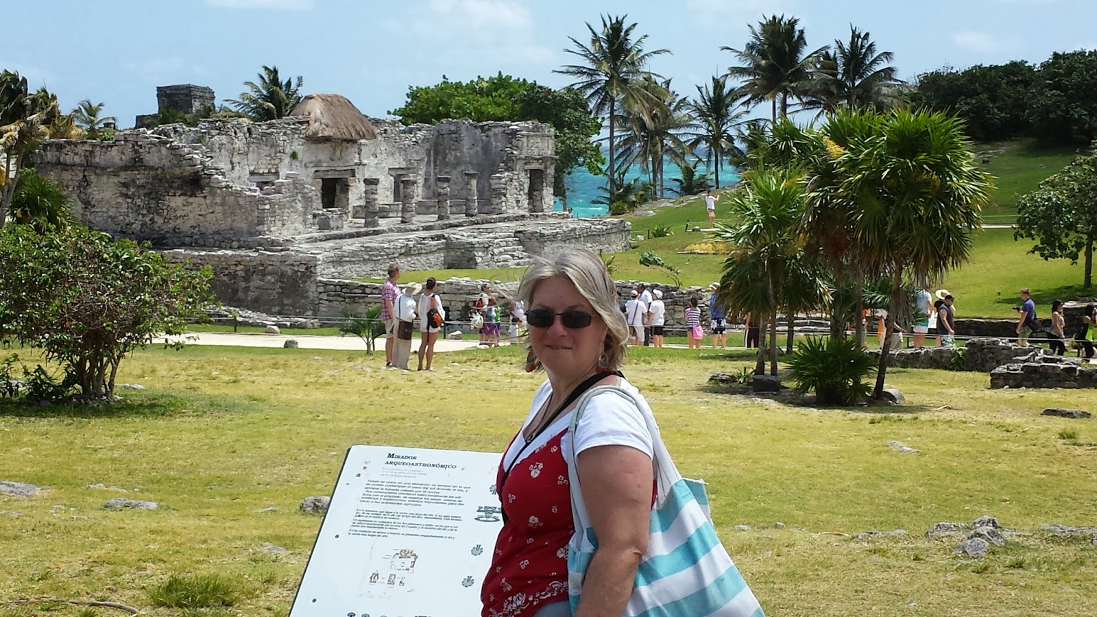
You have to look closely, but in the center of the picture is a Coti digging along the path. Tulum is a walled city built on 40 foot cliffs of the Caribbean Ocean. Wow! The buildings don't compare in grandeur of Coba or Chichen Itza but the site taken as a whole was....so....beautiful!

Tulum is the most visited ruin on the Yucatan so we were there as early as we could manage. The tour buses start arriving around 11 am. We got there around 10 am.


Tulum was part of a series of Maya forts and trading outposts established along the Caribbean coat from the Gulf of Mexico as far south as Honduras.

  |
| The sign says that this is a turtle beach. Those big sea turtles nest all along the coast. If you are there at the right time of year you can help protect them! |

Tulum's strategic location and convenient beach landing made it a natural hub for traders who plied the coast in massive canoes laden with honey, salt, wax, animal skins, vanilla, obsidian, amber and such. Today just tourists cooling off.

Our first stop was Casa del Cenote. A two room structure that we could not enter where people would go for their drinking water. The water is no longer drinkable (salt water intrusion).

The walls were really thick. Note the Maya style arch


Next we wandered over to the Temple of the Wind on the cliffs. We have lots of pictures of this so hang in there! It was so cool because....
 x
x
right there in the center of this building was a carving of an upside down man....


You can see it better here...yeah, this is the temple of the descending God...makes you think of 3rd Nephi huh? If you were carving in rock and wanted to show something going down, wouldn't you put its head down too? We learned after leaving Coba, that the pyramid we climbed had a very weathered version of this same descending God at the top. Interesting huh.... The building was built crooked on purpose, but we never did find out why. Next to this temple was the main pyramid, El Castillo, 40 feet high. Like the others, it was built in phases. No climbing here either. There are frescos inside, but we were not allowed up the steps....
 |
| View of the House of Columns or Royal Palace |

I am pretty sure this is the Great Palace or House of the Columns which likely served as residential quarters for Tulum's royal court and head honchos.


The House of Halach Uinic is a Maya term for king or ruler and this structure seems to have been a shrine for the Descending God. It may have been painted red or blue at one time and highly ornamented but is now highly deteriorated.
 |
| This guy and his buddys seemed to enjoy the place very much! |
 |
| This gives you and idea of the thickness of the walls |
 |
| Everything was made of piled rocks held together with this amazing mortar. Our buidlings today could not stand for thousands of years and withstand hundreds of sea storms and still be standing. It made me feel very temporary! |
 |
| Wall went all the way to the cliffs |
 |
| Corner guard house |
The walls were thick with arches holding up the passages through them. We imagined guards posted and walking the walls. In each corner there was a guard house. Tulum was a refuge when the Spanish arrived and people lived there on and off afterwards.


A nice lady offered to take our picture from this vantage point looking out over the site.

Another beautiful pathway . It was time to figure out how we were going to get back to the ferry. We could wait for the bus to come, but we found this nice AC'd collectivo instead for $4!

A collectivo is a 10 passenger van that they cram with more like 15 people. The van would not leave Tulum until it was full...like I said it was AC'd so we survived the wait. When it was full, the driver flew down the road and pulled over to let people out where (and I mean whereever) they wanted along the road back to Playa....he would also stop and pick up people heading our way. I thought is was a great economical way to travel...if you weren't in too big of a hurry....we hoped to catch the ferry, which we did by running! Yes Tim ran too and the vendors tried to discourage us all the way, saying we wouldn't make it and we should stay for a cool drink instead! Fortunately we had already purchased round trip tickets, they held the boat or rather let us through the closed gate and we made it. Great day!
Day six: San Gervasio and the rest of Cozumel
This was the day we planned to tour Cozumel. We had been into San Miguel in the evening after the Cruise ships left, but we (OK maybe just me) wanted to see the ruins and the rest of the island. By now, Tim was a pro driver, so we rented a car from a very nice place in San Miguel and had a road trip! First stop--you guessed it--ruins!
San Gervasio was easy to find. It was kind of crazy though, we had to pay twice...first booth might have been for parking under a shade tree, and the second was to the archeological society maybe. We never did figure it out! This was waiting for us just inside the gate. A nice village with vendors. But then a few steps later we were into the ruins.
 |
| There was place to wash your feet; the paths must be muddy when it rains |
There are more than 30 ruins identified on Cozumel, but San Gervasio is the largest. Incidently, our car rental guy told us that he had ruins on his property. They are everywhere!
 |
 |
If I remember correctly this is Plaza Central, the seat of power, surrounded by various low structures in various states of decay. The columns held up a wood beamed structure. Tombs were discovered below. Probably a place for public gatherings and such.
It is believed the area around San Gervasio was populated as early as 300 AD. Early archaelologists excavating the ruins found a crypt containing 50 skeletons along with numerous Spanish beads; the bodies are thought to be those of 16th century Maya who died from diseases brought by the conquistadors.


It is believed that hundreds of thousands of Maya women made the journey to Isla Cozumel, 12 miles from the mainland for fertility, childbirth and healing at the temple of Ixchel. Considering the apparent significance of the site, it is amazing that the temple is so modest. This is called Ka'na Nah or tall house.


Inside you could still see some of the colors on the interior murals.


Nohoch Nah or large house was built on top of a platform and may have been used by pilgrims to make an offering upon entering or leaving San Gervasio. It was orginally covered in stucco and painted a multitude of colors.


The cool part for me were the roads or sache'. The entire site is quite large and all connected by these sache'. They are edged and elevated like the turnpikes on our NW trails. I image that crushed stone was tossed on top to even out the surface and would have been a blessing during the rains that would have made the mud a nightmare!

The arch served an an entrance or exit to the city. The Maya never developed a "true" archway that uses a keystone, but managed to construct remarkably resilient arches using the corbeled method of stacking flat stones on either side of an opening, each stone overlapping the previous one, until they met in the middle or were spanned by a long capstone. We saw them everywhere at every ruin we visited on our trip. Once again I was thinking of BOM stories when it said and I caused roads to be built....yeah, I guess I am a seminary teacher...
We were ready for a change of scene. I had seen my pyramids and ruins and we were ready for a drive.

On the Caribbean side of Cozumel the island changes personality a bit. The jungle is only about 6 feet tall, lots of short palms and the sea is completely tourquoise! Sand on the beaches with ironstone just underneath. The waves are rough and intimidating too. We pulled over and took pictures.
 |
| The road on the Caribbean side |
 |
 |
 |
As we drove along we saw there was a separate path for mopeds and these restaurants in the more protected stretches of beach. With a small purchase you can hang out and swim on their beaches. We stopped at one, dug our toes into the sand and had a soda--felt like a commercial only without the beer. I can now say that I can add the Caribbean to the list of oceans my toes have been in....hmmm....maybe a new bucket list item to add --dip my toes into all the oceans on the planet... the water was warm and shells teeny.
On this side of the island there was a nature reserve with a light house to visit. Tim negotiated the fee and we drove in to check it out.
 |
| The road was unpaved and jungle lined much of the way in |
 |
| Occasionally you would get a peek-a-boo of the ocean. You could not hang out on these turtle beaches, just look |
 |
| Our first stop was to see the SALT WATER CROCS in the lagoon! |


It was a big lagoon and we saw one crocodile, it was small about 8 feet long. The boardwalk out over the marsh was kind of cool. The angle of the light let us see all kinds of fish in the water. Fortunately the wind kept the bugs off! Oh yeah, some more ruins, but there was no indication of its purpose.
 |
| The color of the water was so striking |
Next stop was the light house which we were able to climb. It was steep and reminded me of climbing those towers in Astoria. There was only room for one person on the stairs at a time. We didn't take a picture of the lighthouse, but the views from the top instead!
 |
 |
| views of the turtle beaches and the lighthouse museum grounds |
 |
| Looking east from the top of the lighthouse |
 |
| Looking west from the top of the lighthouse |
 |
| View of the lagoons where the crocs live and the road out to where people go to scuba |
 |
| The low walls separating the beach from the light house was made of this. Looks like coral to me, it was heavy and sounded like a hallow hunk of cement when you dropped it. |
 |
| We found these flowers along the road |
It was another successful day touring this part of Mexico; time to return to the hotel. We got to keep the car overnight and return it at the airport so we didn't have to pay for a taxi. Each night we would watch the cruise ships leave and the sun set. We really enjoyed our visit. There's a reason for all of the country songs about Mexican islands. The people are kind and work hard, the beaches are stunning and the heat does help you unwind--but so does the air conditioning!
 |
| cruise ship leaving |
 |
Day Seven: Home
After breakfast we drove to the car rental place near the airport, returned the car and got a ride to the terminal. Customs and bag check was very light in Mexico. However, it wasn't light when we got to Houston! Time was really tight for us to make our connecting flight and we were hungry so we paid a small fortune for a pre-made sandwich, chips and a drink and ran to our gate! In Seattle we had a bit of trial waiting for our car to be unearthed from the long term parking place we had left our car (OK I got grumpy waiting....it wasn't like they didn't know what day we were coming in....they could have done the move before we got there... where were those nice island folks?), but we got it and made it home around 10 pm. It was a long day. Happily, we had planned our trip with a weekend to get organized before having to go back to daily life.
My first time out of the country was a dream come true! Nice bonus that I got to scratch an item off my bucket list---and added a few more to it!
It is nice to be home. Until our next adventure! --Tim and Peggy
One last side note: I had to go to the grocery store the next morning after our return home--we needed to restock. Although we were only gone a week, I was struck at the stark difference between American stores and the ones we visited in Mexico--the prices in Mexico were cheap yes, but with few choices. Our stores had lots of choices--almost an overwhelming number of them --imagine an entire isle of breakfast cereal instead of only three or 18 kinds of cheddar instead of one. There was a Walmart in Playa del Carmen--now I kinda wish we had taken a peek!
Love the pictures and the details! You left a lot out when talking about it. Still very jealous. Love you guys
ReplyDelete